 | ||||||
| ||||||
| ||||||

JOHN HARPER MONTGOMERY b: 1 Mar 1793
A son of Thomas Montgomery and Rebecca Harper. Moved to Illinois in 1845 with his wife, Malinda Platt, and son John Nelson Montgomery and his wife, Luceva Ward.
"Moved early in life to Western Pennsylvania (Crawford County)", or so said J. Ivor Montgomery when he wrote his grandfather's history for the publication, "History of LaSalle County, 1883".
John Harper Montgomery is listed as a Private in the War of 1812, in Captain John Reed's Company, 3rd Sub-legion, from the Official "Roster of Ohio Soldiers in War of 1812", Vol.1, Page 59. Captain John Reed's Company served from August 23 until November 30, 1812, and from January 1 until March, 1813.
On April 16, 1816, John H. Montgomery was one of 44 people who obtained a parcel of property from Abraham and Elisabeth Tappan at the center of the Village of Madison to be used as common space (now Village Park) which also included "a part of said common not exceeding 4 rods width and on the east side, may be occupied and improved as a burying ground." See "Copy of Deed to Madison Public Square" (Taken from an old Madison Township Record Book). There were no burials in this location.
This location was later (1817) deemed to be unacceptable as a burying ground and an exchange of property was arranged, basically a trade, locating the burial ground kitty-corner to the NW corner of West Main and Eagle Streets, with a name of Centreville Cemetery. The graves subsequently placed therein were moved in 1854 to a better resting place (Fairview Cemetery?) and this cemetery lot abandoned. Did those moved graves include the graves of Thomas and Rebecca Montgomery, John H.'s parents? Were some of the Centreville Cemetery graves overlooked in the move of 1854? Thomas and Rebecca are yet to be discovered.
Married Malinda Platt, 29 April 1819, in the Township of Denmark, Ashtabula County, Ohio, according to Probate Court records found at the County Seat / Archeological Archives of Ashtabula County, Jefferson, OH. In 1819, the area of Denmark Township included the areas presently occupied by Denmark Township and Dorset Township which is immediately to the south of, and equal in size to, Denmark Township - 6 miles E-W and 12 miles N-S. It is in this area the home / church / location of their wedding was situated.
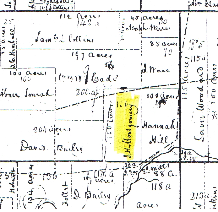
Besides the 100 acres his father "pioneered" in 1811, he owned other property in Madison Township, Geauga (Lake) County, OH, in 1825. From the Chardon (OH) Land Records office, July 31, 2002 (Courtesy of the Ashtabula County Historical Society):
- On November 10, 1825, John H. and Malinda Montgomery and Ashley and Dyantha Montgomery Follett (sister and brother-in-law of John H.), for $1,000.00, sold 113 "rods" of land (about 70% of 1 acre), containing two springs of water and one distillery, located at the following location:
- " . . . situated in Township number eleven in the sixth range of townships in the Connecticut Western Reserve in the State of Ohio, and which is also the County of Geauga, and is known by being the southeast corner of lot number nine in said township, and is bounded as follows, to wit: beginning a few rods west of the widow Hannah Hills now dwelling house, at a stake and stones on the bank of the gully on the south east side of the road that runs to Emerson's Mills, thence across the gully aforesaid and along the road eleven rods (181.5 feet) to a stake and stones on the bank of the river; thence from the place of beginning in a right angle from said road twelve and a half rods (206.25') to a stake and stones on the bank of said River, and from thence along said bank of the river to the third mentioned stake and stones, supposed to contain one hundred and thirteen rods of land, be the same, more or less. And also a privilege of using and conducting a quantity of water sufficient for all the purposes of a distillery from two springs of water situated on tract number nine on the northwest side of said road to the distillery which is lately erected on the premises by Noble Olmstead, be the same, more or less . . . unto them the said Elisha Sperry & Simon Gajer . . ."
His sister Dyantha and her husband Ashley grew a family and remained in Madison, OH, until about 1830 (see Dyantha's notes).
Between 1825 and 1826, he must have moved to the Richmond Township, Ashtabula County, OH / Conneaut Township, Crawford County, PA area, closer to Malinda's Platt family connections, as one of his sons was born in Crawford County, PA.
On Richmond Township, OH: "Once a part of Jefferson, Denmark and Pierpont Townships, a final separation resulted in the organization of Richmond Township, in 1828. At the organizational meeting, the following were chosen to serve the residents: John H. Montgomery, Levi Brown and David Prindle, Trustees; . . ."
Where he and Malinda were living in Richmond Township in 1828 can probably be found by examining property records for the names Montgomery and / or Platt. The Platt name was prominent and plentiful across the state line around PennLine, PA, and along both sides of the state line north and south for about 12 miles.
As noted in the 1830 Federal Census, sometime between 1828 and 1830 he had moved to Wayne Township, Ashtabula County, OH. Shown in the 1830 Census as "J. H. Montgomery" living in Wayne Township, as noted on page 113 of the Census Report.
His children have varying birth places on various US Censuses, from Pennsylvania to Ohio, and not necessarily in the order of birth. This might be attributed to having family (the Platts) on both sides of the State Line and the possibility of having moved across the state line to live in the years between 1830 and 1840. It is also possible he and Malinda may have lived with some of their Platt relatives, at some time, in PA and / or in OH.
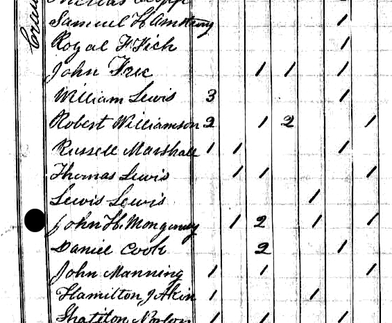
Sometime between 1830 and 1840 he moved to Crawford County, PA. The US Census of 1840 shows John H. Montgomery living in North Shenango Township, Crawford County, PA. The "profile" of his family matches the Census. (1840 Census: Montgomery was spelled "Mongomey" on the Census page and recently incorrectly transcribed as "Mongonesy" to Ancestry.com website). The 1840 Census also denotes 2 individuals in the John H household as working in a trade other than agriculture. This working trade could have been saddle & harness manufacturing as record of such a business was recorded in the township on 16 May 1835 to a "Montgomery, J". (Crawford County Historical Society)
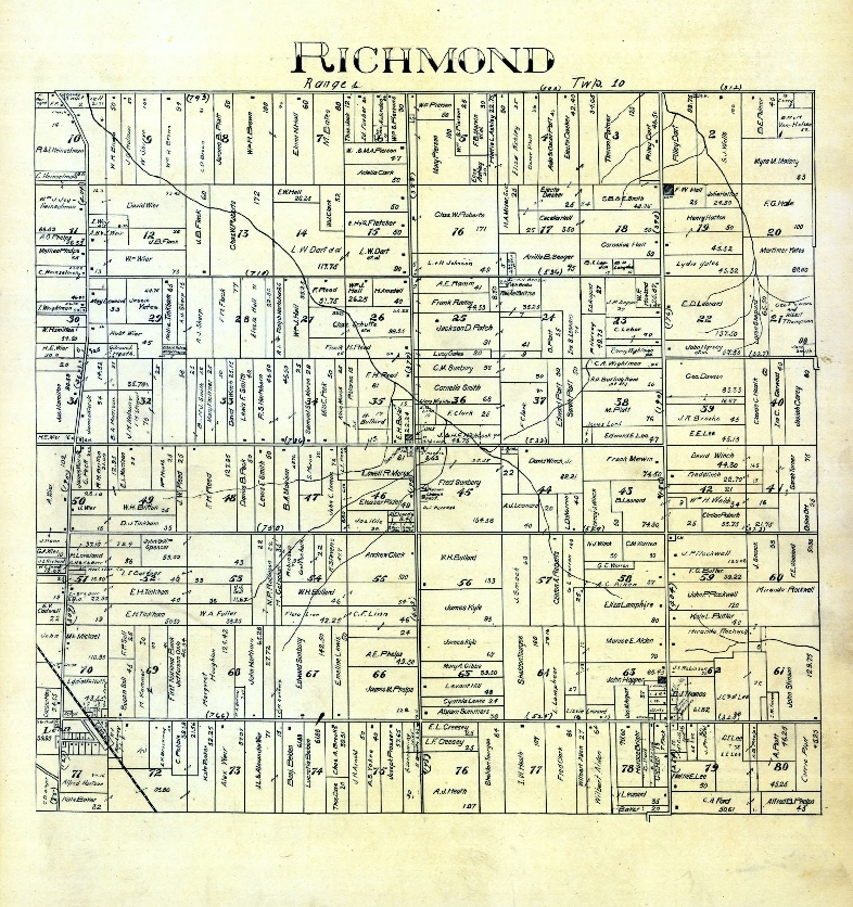
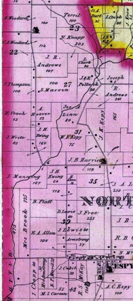
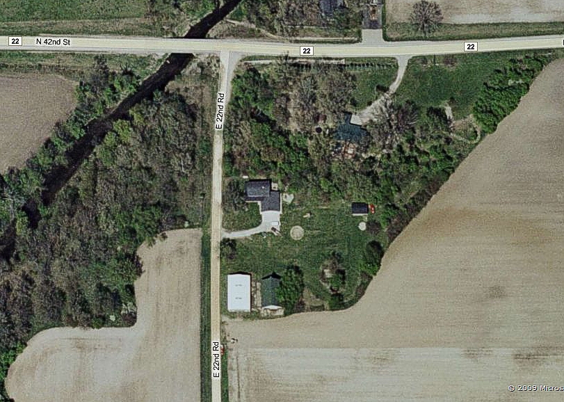
A deduction as to the location of residence in 1840 of John H and Malinda Platt Montgomery: On the 1876 Atlas Map of North Shenango Township is the property denoted "B. Platt", which was purchased in 1846 from a Mr. Rockhill and later owned by Hezekiah Platt, brother of Malinda Platt Montgomery who was the wife of John Harper Montgomery. Stradling the road just north of Espyville is the "B. Platt" property, 118 acres. On either side (south to north) of the "B. Platt" property is "D. Lewis", south, and "H. Aken", north. To the south of "D. Lewis" is "J. Lewis", and then "Armstrong". These surnames are on the same 1840 Census page and in proximity to "John H Montgomery".
In 1876, If you traveled along the N-S road, in a south to north direction, this surname pattern emerges (using the 1876 Map):
. . . Armstrong, Lewis, Lewis, Platt (Montgomery), Ewing, Manning, Aken . . .
On the 1840 Census, the names on the page run as follows:
. . . Armstrong, Fick, Free, Lewis, Williamson, Marshall, Lewis, Lewis, Montgomery (Platt?), Cook, Manning, Akin (Aken), etc.
Except for "Fick, Lewis, Williamson, and Marshall", the 1840 Census name / property sequence matches the 1876 Map sequence. For the "Fick, Lewis, Williamson, Marshall" households, the Census taker may have been working a full day between Armstrong and Lewis in another area close by. And, being 36 years after the Census, names on the 1876 properties surely changed a bit, as did "B. Platt", which may account for "Cook" becoming "Ewing" from 1840 to 1876. But the name sequences sure look eerily close.
Therefore, not yet verified but through deduction, it is believed the "B. Platt" property on the 1876 Map was once farmed by "B. Platt's" Aunt and Uncle, Malinda Platt Montgomery and John Harper Montgomery, between 1830 and 1845, surely 1840.
Hezekiah Platt (Malinda Platt Montgomery's brother) purchased the property from a Thomas C. Rockhill, Jr., in 1846. Mr. Rockhill appears to have gotten the property out of a land grant. In 1876, it was owned by a Betsey Platt (B. Platt) and she appears to have purchased it from Hezekiah Platt's heirs in the early 1870's.
Hezekiah Platt purchased this land in 1846, right after John and Malinda Montgomery moved, lock, stock and barrel, to Illinois, and Hezekiah later gave / left it to his (Platt) heirs. It is surmized that John and Malinda farmed the land for Mr. Rockhill, recommending Mr. Rockhill sell it to Malinda's brother, Hezekiah, or a similar arrangement, upon the exiting to Illinois by John and Malinda. The sale to Hezekiah in 1846 may have simply waited from the end of the farming season in 1845, when John and Malinda left for Illinois, until Spring of 1846, just prior to the growing season.
From "A Pioneer Outline History of Northwestern Pennsylvania", by W. D. McKnight, M.D., 1905 regarding Crawford County:
"STATISTICS OF 1840 - NORTHWESTERN PENNSYLVANIA
In 1840, there were in the northwest purchase but nine erected and complete counties, - to wit, Butler, Crawford, Jefferson, McKean, Mercer, Potter, Tioga, Venango, and Warren. Butler County had twenty-two thousand three hundred and seventy-one people, and the county contained fifteen towns, townships, and boroughs, - to wit, Buffalo, Clearfield, Donegal, Centre, Parker, Venango, Mercer, Middlesex, Cherry, Slippery Rock, Butler Borough, Butler, Muddy Creek, Conoquenessing, and Cranberry. In that year, Butler County had three charcoal furnaces, with an output of six hundred and twenty-five tons. The amount of coal mined in the county was one hundred and two thousand three hundred bushels; number of miners employed, thirty-one. Retail stores in the county, fifty-five, with a capital of $172,850. Value of hats and caps manufactured in the county: $3750. Number of tanneries: twenty-two. Number of men employed: thirty-one. Number of distilleries: thirteen. Number of breweries: two. Number of printing-offices: two. Number of oil-mills: four. Number of saw-mills: sixty-four. Number of gristmills: fifty-four.
CRAWFORD COUNTY - 1840
In 1840, Crawford County had thirty-seven thousand seven hundred and twenty-four people, and the county contained twenty-seven towns, townships, and boroughs, - to wit, South Shenango, Greenwood, Venango, Fallowfield, Randolph, Woodcock, Vernon, Mead, Summerhill, Sadsbury, Meadville Borough, Sparta, Oil Creek, Richmond, Rome, Cossawago, Beaver, Wayne, Bloomfield, Rockdale, Athens, Troy, Hayfield, Spring, Conneaut, Fairfield, and North Shenango. In that year Crawford County had two charcoal furnaces. The coal output was two thousand tons. Number of miners employed: six. Retail stores in the county, sixty-two, with a capital of $196,200. Value of hats and caps manufactured: four thousand. Number of tanneries: fourteen. Number of men employed twenty-six. Number of distilleries: fourteen. Number of breweries: one. Number of paper-mills: two. Number of printing offices: two. Number of grist-mills: thirty-nine. Number of saw-mills: one hundred and twenty-nine. Number of oil-mills: two. These were flax- seed mills, making linseed oil. These mills were quite numerous in Northwestern Pennsylvania, and an industry of importance and profit.?
ILLINOIS - 1845
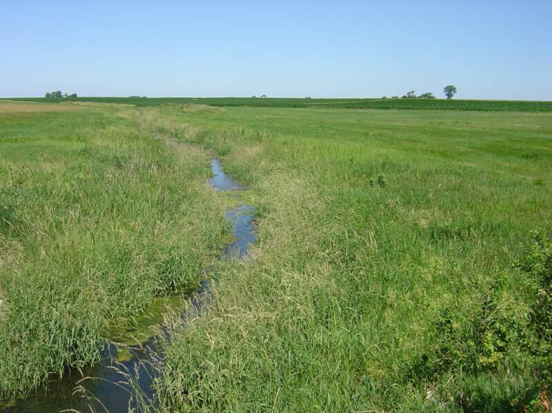
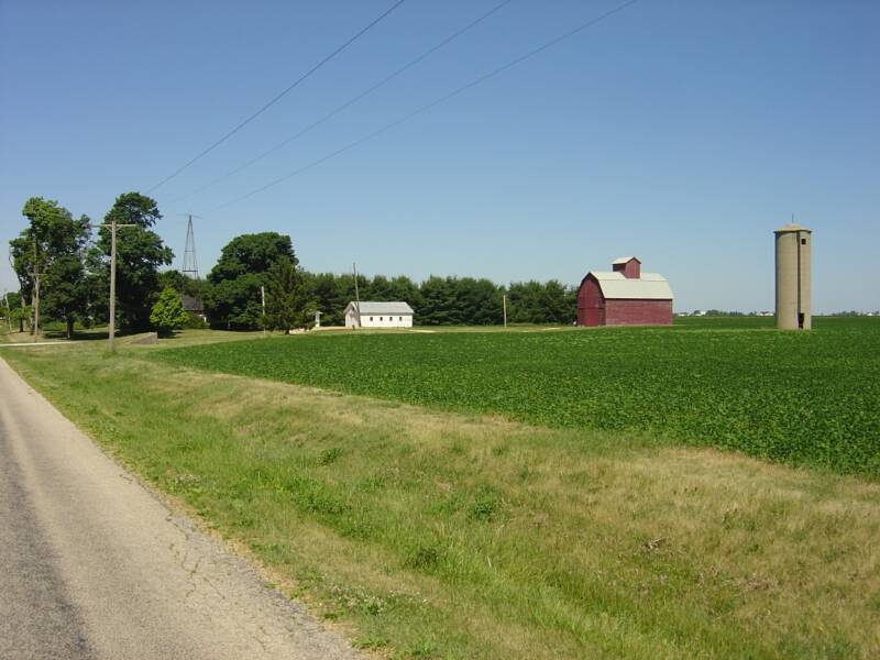
John Harper and son John Nelson Montgomery moved their families to Illinois in 1845, from Crawford County, PA. They settled at Buck Creek, north of Ottawa, IL.
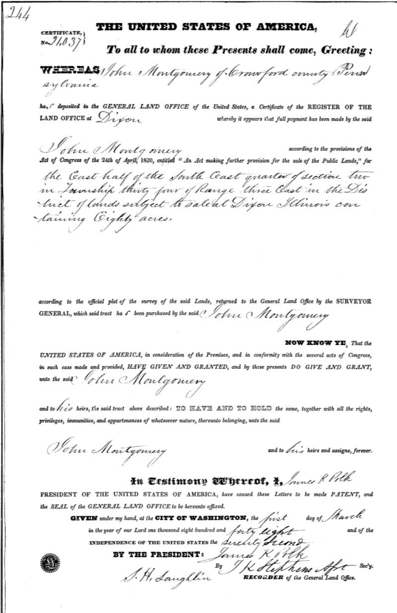
According to documents located at LaSalle County Courthouse, Ottawa, IL, and in the Illinois State Archives, the first piece of property purchased by John Harper Montgomery in Illinois was 80 acres, in a Federal Transaction, for $1.25 an acre ($100.00), November 24, 1845, located 6 miles north of Ottawa, IL, in Dayton Township, about 1/8 mile west of current Illinois Route 23 along what is now Wedron Road, near a creek (Buck Creek): "The East 1/2 of the Southeast 1/4, Section 2, Township 34N (Dayton), Range 3East, 3rd Principle Meridian."
A Federal Land Patent for this parcel, Certificate No. 21.037, was issued to "John Montgomery, of Crawford County, Pennsylvania", on March 1, 1848, at the General Land Office, Dixon, IL.
According to the Federal Census of 1850, the entry for John Harper Montgomery, and the rest of his family living together under one roof, was followed by the entry for a Brower family together with a man named Beach, which had to have been directly across the road (the next stop for the census taker), as indicated on the Plat of the Township for the area for the given timeframe.
According to the Federal 1850 Census of LaSalle County he was 56 years of age in 1850. John Harper was born in 1793, according to his age calculation from his obituary, making him 56 at the time of a summer Census, enumerated in November of 1850.
The 1855 Illinois Census shows John H and Malinda Montgomery living as one family unit on the farm at Buck Creek with son Benjamin F. Montgomery, as does the 1860 Census.
The 1865 Census shows John H and Malinda Montgomery living with son John Nelson and wife Amanda Montgomery in Serena Township, LaSalle County, IL.
In his Personal Journal entry on March 26, 1883, J. Ivor Montgomery, John Harper's first grandson, writes that, from the (Lett) family farm south of Sandwich, IL, he " . . . drove to Ottawa via Bostwick's in Freedom; stopping at Ed. Temples in Serena + I. (Irenus, see 1850 census) Browers + A.E. (Ashbel - see 1850 census) Beache's in Dayton: I got tea and supper at Beache's. He had cut - today - a cottonwood tree by the front gate that Grandfather had planted; I counted 32 rings on it." "Grandfather" would have been John Harper Montgomery and the tree would have been planted ca. 1850-1851, the time John Harper purchased the land / farm from James Stout for $1.00. Later Dayton Township Plats show the farm land being owned by a "Beach.""
Ohio, Pennsylvania & Illinois . . .
John Harper Montgomery
/\ Denmark Township,
Ashtabula County (1875)
Buck Creek, LaSalle County, IL
John Harper Montgomery Farm site, ca. 2004
< North Shenango Township, Crawford County, PA.
"B. Platt" farm was John and Malinda's farm before they moved to Illinois in 1845
Signature of John Harper Montgomery,
ca 1860, from a book given to his son,
James Ivor Montgomery
<<
Pioneer Home location on 100 acres
settled by Thomas and Rebecca Montgomery,
in 1811.
A Montgomery Family Genealogy
As recorded and developed by W.J. Montgomery
| ||||||
| ||||||
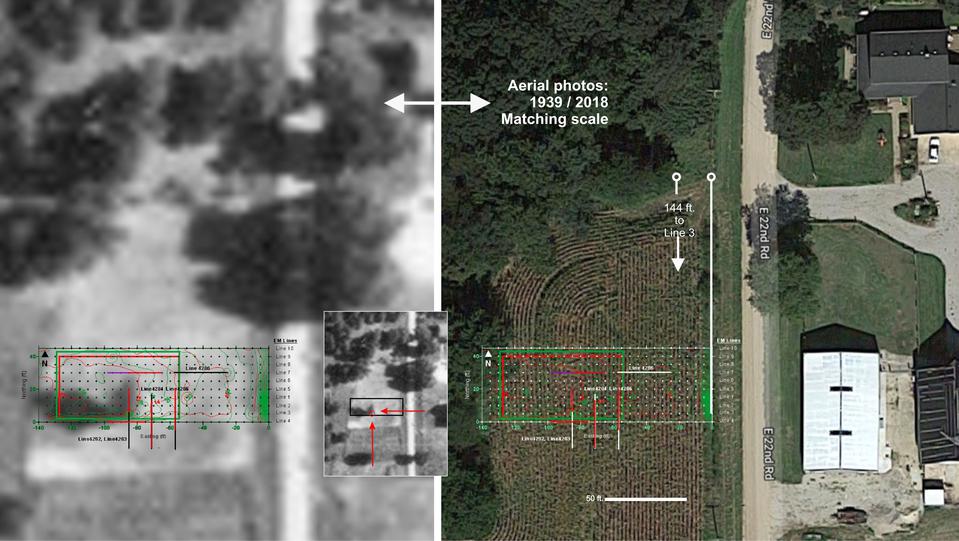
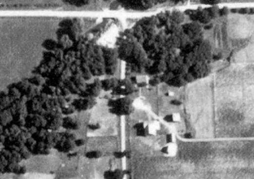
1939 USGS aerial
2009 Satellite photo
| ||||||
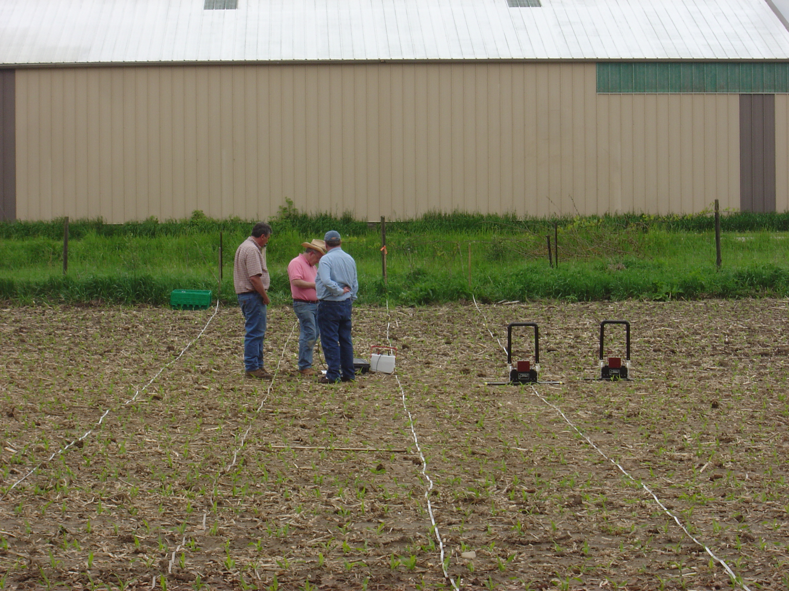
May 15, 2010 - CSI
Cemetery Site Investigation
| ||||||
| ||||||
| ||||||
| ||||||
A NEW WAY TO SEARCH:
Soon there will be more definitive proof of burials / graves at this location. (above)
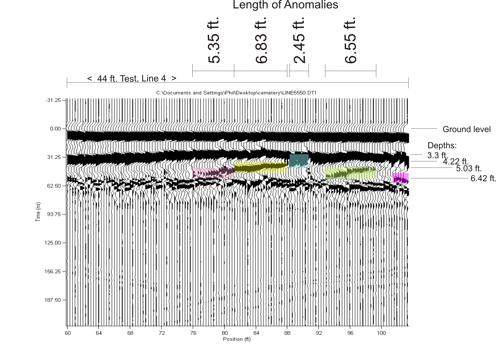
On May 15, 2010, an investigative session took place with an academic geologist using GPR, Ground Penetrating Radar, and using EM, Electromagnetic imaging, so as to determine the locations of some of the reported 21-22 graves at this Springstead Family Burial Ground (SFBG). There were only 4-5 adults buried here (over age 13), the remainder were children.
The large bush in the center of this area on the photo from 1939 was reportedly a mature lilac bush planted at the grave of Sarah Maria Springstead, 19 year old daughter of Hiram and Maria Lett Springstead, who died of diptheria.
Sarah died 1879.
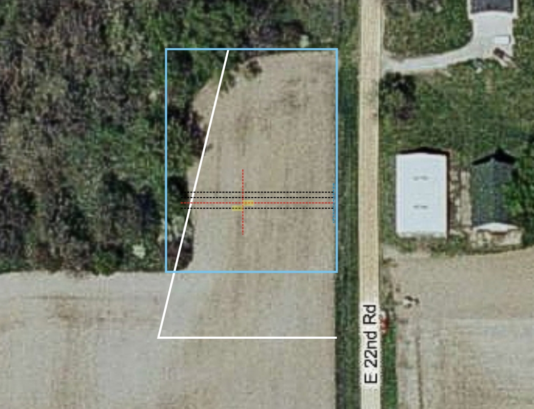
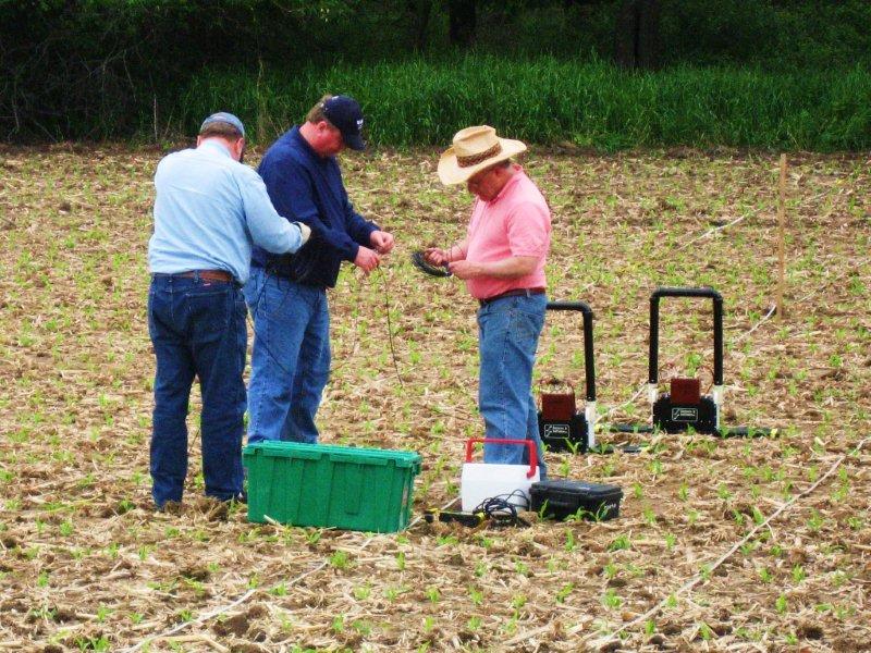
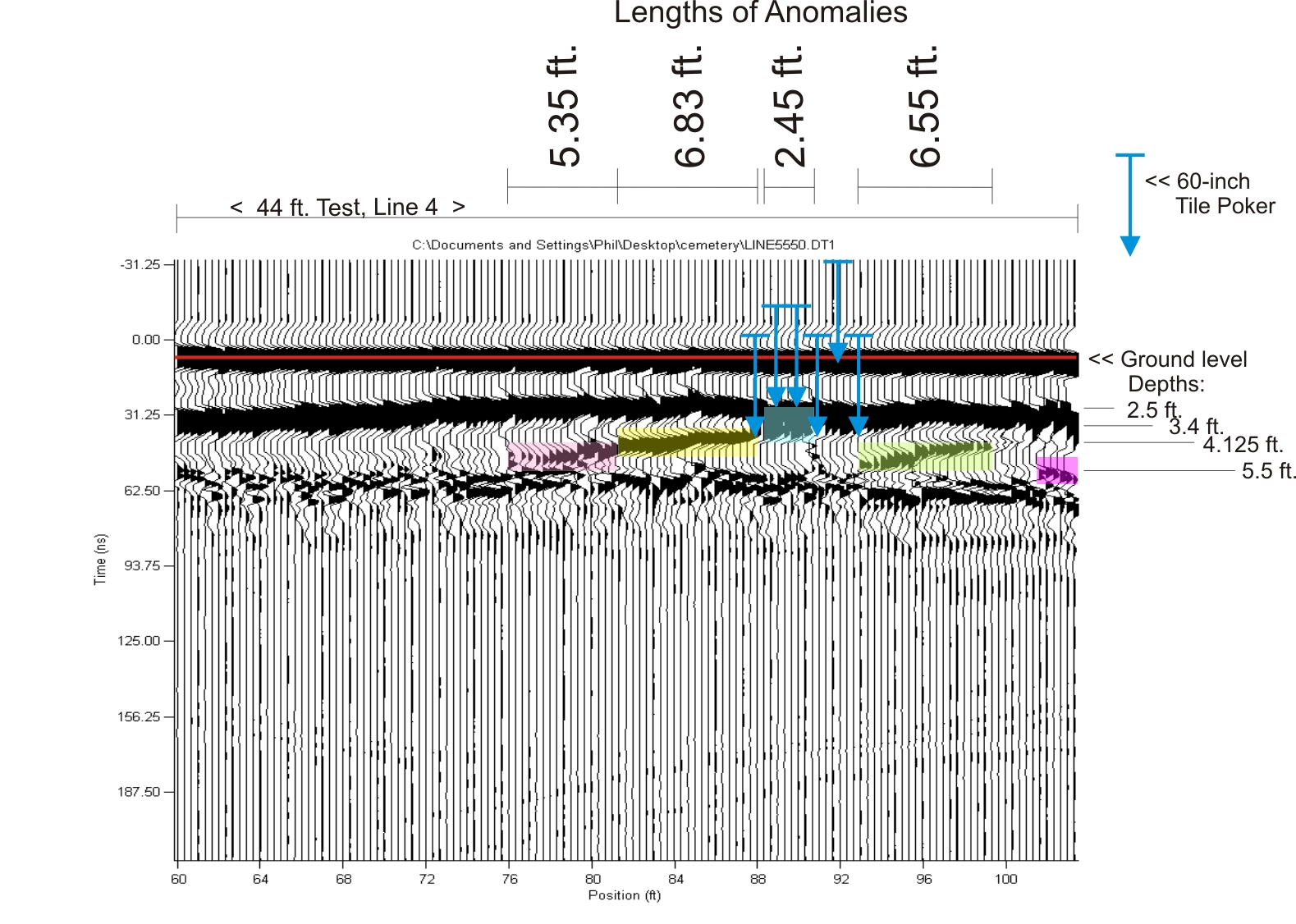
UPDATE: On March 19, 2011, a "poke test" was done by the author, along GPR Line 4 (above graph) with a 60-inch Tile Poker. Inserted into the earth at various points along Line 4, with main center-of-interest being the measured location of the 1879 Lilac Bush (N-S measurement intersection - see 2009 Satellite photo enlargement above), the results were more than astounding as the depths of insertion aligned with the GPR findings . . . see these results at right with the Tile Poker indicated in blue. The most firm resistance came at the location of the darkest, largest anomaly - perhaps a large headstone?
Forward to 2018 . . .
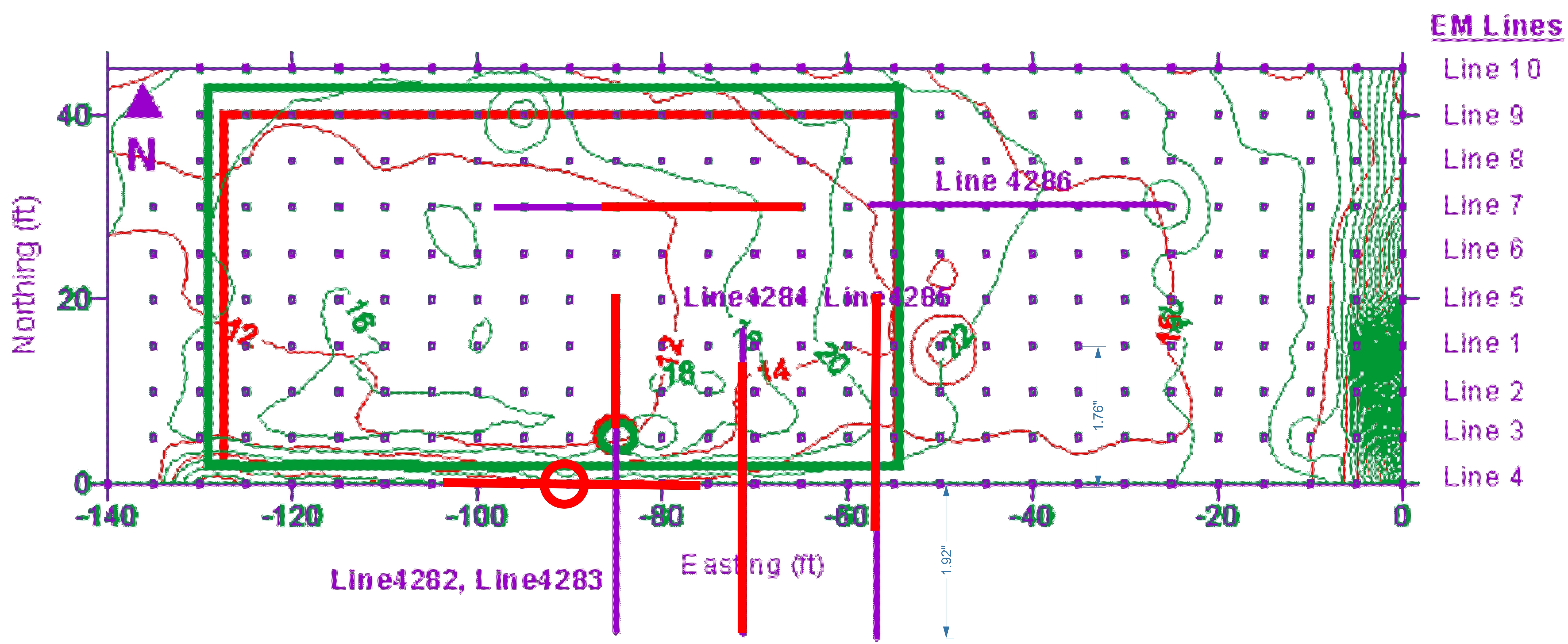
More GPR and EM investigations were done on April 28, 2018. The below images show the 2010 and 2018 findings combined and overlapped onto the original 1939 aerial photo and the location of the suspected Lilac Tree in the 1939 photo as well onto present-day aerial photography for alignment. Another four (4) "Lines" were done with GPR in 2018.
The results were most revealing.
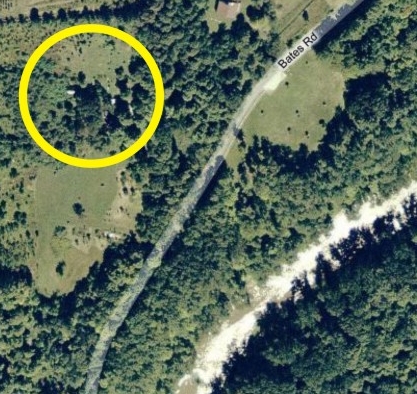
^ Above Plat Map showing "Cemetery Cross" at the upper "T" intersection on the "H. Springstead" lot which crosses the road, next to the Little Indian Creek. Also shown above (blue circle), on the second road south of the cemetery location is "W. Dondanville", which is the location of John Harper's son's home prior to 1870, at the time of his death in 1867.
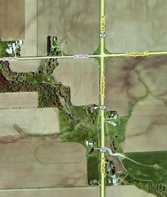
Photos at right are aerial views of location of the Springstead Family Burial Ground (SFBG),
according to records and interviews.
John H. died at the house of his son, John Nelson Montgomery, in Serena (Township), LaSalle County, IL, December 12, 1867, according to his printed obituary. His grave has not been found, as of March 2007. He is believed to be buried in the Springstead Cemetery (photos at right), near the intersection of Springstead Road and Indian Creek, LaSalle County, IL. (Two of John H's grandchildren who died very young, infant children of John H's son John Nelson and wife Amanda Springstead Montgomery are believed to be in this burial ground. The children passed before that family's move to Iowa in about 1870 - see below).
| ||||||
Sarah Maria Springstead's
1879 Lilac Bush > > > >
| ||||||
| ||||||
| ||||||
| ||||||
| ||||||
^^
SOLID RESISTANCE,
SHORTEST DEPTH, ABOVE LARGEST ANOMALY
> LINE 4 <
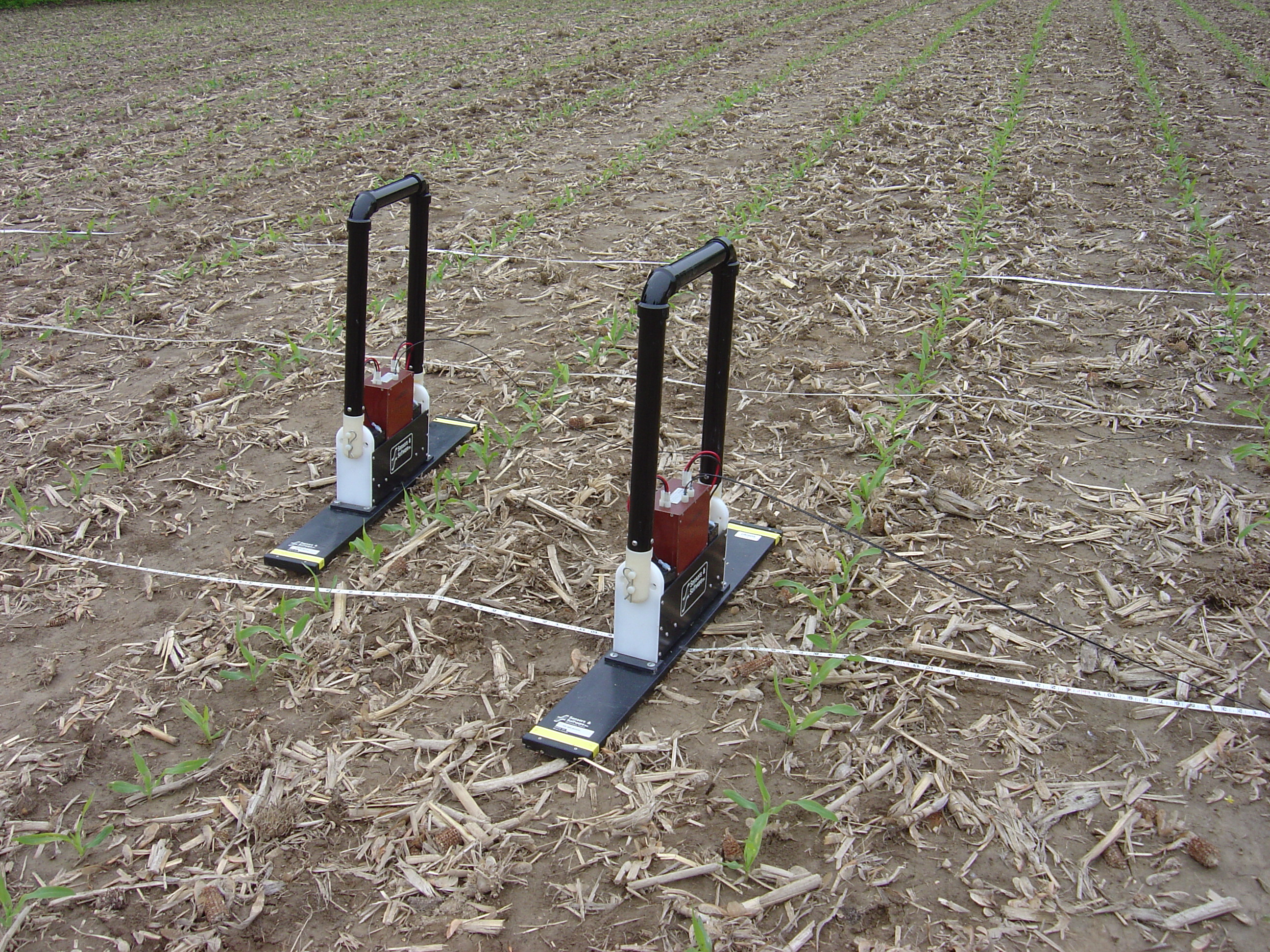
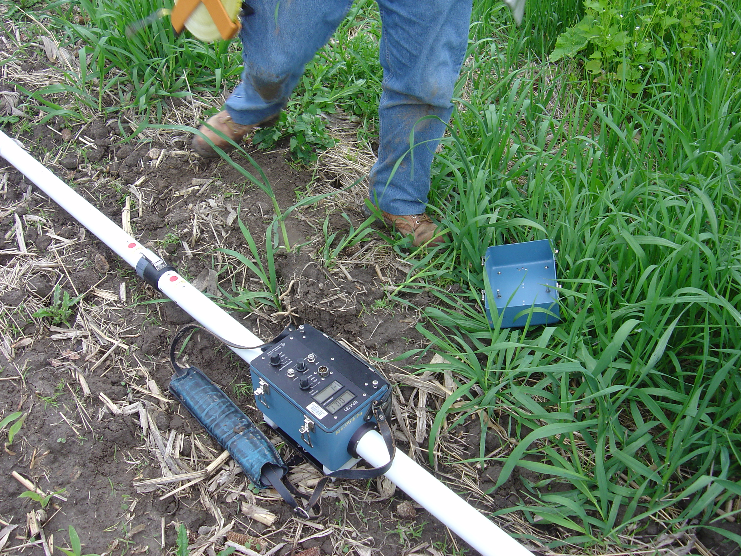
EM Equipment
GPR Equipment:
Readings taken
every 4 inches.
Center point (Lilac Bush):
144 feet south of NE corner of field,
88 feet west, into the field
Lines set out 4-feet apart,
144 feet long, East to West.
GPR
SET UP:
>
<
^
Set up for GPR begins . . .
| ||||||
Red cross-hairs indicate
measured location of
Sarah Maria Springstead's
1879 Lilac Bush, as seen in the 1939 Aerial Photo
and measured from the
scale of the 1939 photo.
V
John Harper Montgomery
farm location,
North of Ottawa, IL
<<<<
Luceva Ward Montgomery d 1850
<<<<
Brower-Hess Cemetery
Right On Target . . . combining 2010 and 2018
> Seen below is an enlargement of the 5-foot grid spacing overlays used above as locators for all "Sections/Lines", using a ground space/area of 45 feet X 140 feet (6,300 sq. ft.).
> Red and green ground contours are a result of EM echoes. Heavy contours at right resulted from the N-S road's ditch line.
> Red and Green rectangles are considered prime areas for burials/anomalies as a result of the EM returns.
> The two 2010 Sections/Lines were along Lines 3 and 4. (Line 4 / 4282 shown, Line 3 / 4281 is not shown along Line 3).
> The N-S Lines 4283, 4284, 4285 and the W-E Line 4286 were done in 2018. (#4286 is shown twice = the all purple 4286 line was flipped so as to have correct West-East orientation.)
> Red portions of each Section/Line are the areas of strongest ground disturbances/anomalies along that Line.
Best of all, the GREEN circle along Line 3 is the original calculated position for the Lilac Tree that appears
on the 1939 USGS / SID N42 E22 aerial photograph. "Right on target"